New online maps reveal history of Reading’s streets
- Explore Victorian Reading online with new map collection
- Zoom in on a particular area to discover more about the hidden history of your house, your street and your community
- 29 maps of selected areas of central Reading available
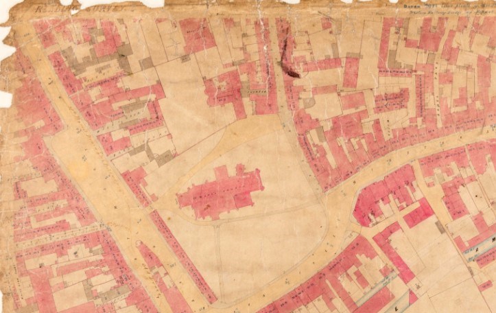
NEW online maps, dating back to the 1850s, have been published this month that provide a glimpse of Reading’s hidden history.
Residents and lovers of history can use the maps to zoom in on particular areas of Reading, to explore the history of a house, street or neighbourhood.
The 29 maps cover the area from the Oxford Road to the west, Reading railway station to the north, London Road to the east, Southampton Street and Whitley Street to the south. Some of the outer areas of modern Reading – such as Caversham and Tilehurst – are not shown since the borough’s boundaries were smaller in the 1850s.
Visit https://maps.berkshirerecordoffice.org.uk to access the maps.
Working in partnership with Reading Council’s High Street Heritage Action Zone project team, the Berkshire Record Office (BRO) has digitised the maps which were drawn up by architect and surveyor John Clacy in 1853 to survey the state of sanitary provision in the town.

Mark Stevens, County Archivist, said: “Victorian Reading comes alive through these highly detailed plans. They offer a chance to admire the work that the town’s engineers did and that we still rely on today to protect us. We’re delighted that High Street Heritage Action Zone funding has allowed them to be digitised for wider use.”
Cllr Karen Rowland, Reading’s Lead Councillor for Culture, Heritage and Recreation, said: “I am so delighted with this project. These fascinating maps are a link between the past and present and can be so useful for those involved in regeneration and conservation projects - along with anyone that is simply curious about their own Victorian home. We are delighted to have these maps now so easily accessible for the public, thanks to our High Street Heritage Action Zone project and the hard work of Berkshire Record Office.
“As a map lover who has spent many a pleasant hour pouring over these wonderful maps at the Berkshire Record Office, I know these maps are virtually the best record we have of Reading from that time period - so precise, you can see where the water intake and output pipes are located in each property! A treasure trove now brought to your desk at home. I hope many people take the time to delve into these and find out more about the rich Victorian history of residents and businesses that helped our bulbs, beer and biscuits history make Reading what it is today.
“It is worth mentioning Historic England has a new ‘Working Class heritage grant’ available for community-led projects that celebrate overlooked historic places. These maps would be an ideal resource for researching towards this project: https://historicengland.org.uk/whats-new/news/grants-to-uncover-nations-hidden-working-class-heritage”
The maps were originally commissioned by Reading’s Local Board of Health, as part of their public health responsibility for monitoring the maintenance of streets, public cleanliness, water supply and sewerage.
This followed from the passing of the first Public Health Act, five years earlier in 1848 - a response to the great cholera epidemics. For the first time, any town with a high death rate had to take responsibility for monitoring public health.
The maps form part of a larger collection of Board of Health material that is housed in the Record Office, in Coley Avenue.
Ends
Notes to editors
Berkshire Record Office
Berkshire Record Office is the joint archives service for the six Berkshire councils. It looks after nearly nine hundred years of historic collections from public authorities and private bodies from across the county. Items from the collections can be consulted for free during opening hours, Tuesday-Friday.
Contact details: Berkshire Record Office, 9 Coley Avenue, Reading RG1 6AF.
Tel: 0118 937 5132
Email: arch@reading.gov.uk
Web: www.berkshirerecordoffice.org.uk
Social Media:
https://twitter.com/BerksArchives
https://www.facebook.com/berkshirerecordoffice/
https://www.instagram.com/berkshirerecordoffice/?hl=en-gb
https://www.youtube.com/channel/UCY08IoTWkRfakAQZ96rmCkw
About High Streets Heritage Action Zones
The High Streets Heritage Action Zones is a £95 million government-funded programme led by Historic England, designed to secure lasting improvements and help breathe new life into our historic high streets for the communities and businesses that use them. Historic England is working with local people and partners to unlock the rich heritage on these high streets, through repair and improvement works as well as arts and cultural programmes, making them more attractive to residents, businesses, tourists and investors.
About Reading’s HSHAZ project
Reading is one of 68 areas of England to receive a share of a £95 million High Street Heritage Action Zone (HSHAZ) fund having secured High Street Heritage Action Zone (HSHAZ) status for three conservation areas in the centre of the town.
As a result, Reading will receive up to £806,500 from Historic England and will match-fund £808,500 to deliver a £1.6 million programme over 3.5 years.
The programme focusses positively on the attributes of the streets’ heritage to future-proof their environment and businesses, making them more attractive, enjoyable and vibrant destinations for people to shop, relax and spend time in.
Reading’s HSHAZ programme is focused on high streets in three Conservation Areas: Castle Hill/Russell Street/Oxford Road; St Mary’s Butts/Castle Street and Market Place/London Street. The major project aims to deliver across three key themes:
- Physical improvements to buildings: including repairs, reinstating lost features, supporting the conversion of historic buildings for new uses and improvement of shared spaces.
- Community engagement: giving local communities a key role in deciding what works they want to see happening on their high street and what sort of place they want it to be.
- Cultural programme: activities and events celebrating the history of the high street and its importance to local communities.
Connect with the project via social media: