Have your say on plans to improve Reading’s pathways and get more people walking
- 12-week public consultation launches today
- Ambition to increase the number of people walking and cycling
- Action plan includes creating new paths and reinstating historic rights of way that have been lost
READING Borough Council is encouraging residents to have their say on ambitious plans to maintain and improve the borough’s rights of way network in a bid to get more people using them.
Securing new pathways and reinstating historic routes that have been lost, are just two of the actions highlighted by the plan, including working with the developers of the Caversham Park estate to allow the use of some paths on the parkland.
The overall goal of the latest Public Rights of Way Improvement Plan is to encourage more people to choose walking and cycling for local and longer journeys. This includes an ambition to increase the number of people walking into the town centre from 29 per cent to 40 per cent by 2036.*
A 12-week public consultation launches today and will close on 19 February 2023. People can have their say online at www.reading.gov.uk/ROWIPConsultation
For further information or to request alternative formats contact: transport@reading.gov.uk
For more information on the Council’s management of public rights of way visit: www.reading.gov.uk/vehicles-roads-and-transport/public-rights-of-way
and view the Improvement Plan here: www.reading.gov.uk/vehicles-roads-and-transport/transport-strategy/rights-of-way-improvement-plan
Some of the existing achievements outlined in the document so far include:
- Resurfacing of key routes in the borough including the River Thames and River Kennet footpaths, with bank repairs alongside the River Thames;
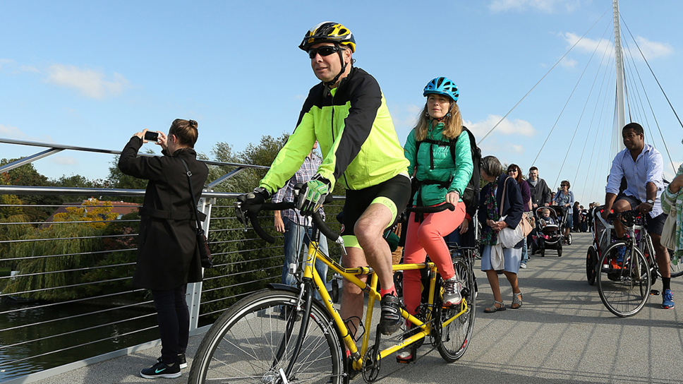
- Construction of Christchurch Bridge, providing enhanced access between the Thames Path and Caversham;
- A new pedestrian bridge installed in west Reading over the railway linking the Thames Towpath (Footpath 1) with the A329 Oxford Road (Footpath 29);
- Modifications at Fobney Lock for better access to cyclists and wheelchair users.

Tony Page, Reading Borough Council’s Lead Councillor for Climate Strategy and Transport said: “Reading has 21 miles of Public Rights of Way across the borough. You may not have even heard of this network – but you may be using it every day! Many of the footpaths are key routes connecting people to destinations such as the town centre, Reading Station, Green Park and Thames Valley Business Park. They are used by people travelling to work and school, as well as many rural-type routes that are used for leisure.
“We’d like to better integrate these routes into Reading’s overall transport network - to provide a better experience, and to encourage more people to choose to walk or cycle for local journeys. It is also part of our wider, long-term transport vision to encourage more people to use healthier active travel options, by enhancing walking and cycling routes across our town.”
“As part of our wider Climate Emergency Strategy, our work on improving walking and cycling routes underlines the Council’s wholehearted commitment to tackling poor air quality which we know exists in parts of Reading. Walking or cycling instead of using the car has many benefits for our physical and mental wellbeing, the health of our local environment and our wallets. Bikes are the most energy-efficient form of transport and can be faster and more predictable than cars for short journeys. Cycling or walking regularly can keep you fit, save you money (no tax, no fuel, no fares) and it’s one of the most environmentally-friendly ways to travel."
For the future, the action plan proposes:
- Identifying new paths – including creating new paths as part of new developments;
- Reviewing suggestions for historic routes and exploring options with the aim to claim or reinstate them;
- Focussing on removing barriers for cyclists – such as gates and narrow paths, and on paths for those with restricted mobility and visually impaired such as gates, surface, gradient, and width;
- Long-term addition of street-lights on existing dark paths.
Cllr Page continued: “We are also looking at historic Rights of Way that are not included in the current network list. A topical example of this is the land on the Caversham Park Estate in Emmer Green. We know there is a great deal of local support for providing public access to this beautiful parkland. This is now something we want to take forward with the developers of this site and we have included within our action plan.
“It is vital we look after the network and improve it – and our latest Rights of Way Improvement Plan seeks to achieve that very goal. I’d like to encourage everyone to have a say on our Public Rights of Way consultation, which launches today for 12 weeks.”

The draft Public Rights of Way Improvement Plan 2 (2023-33) includes a detailed action plan with seven key themes:
- To update and improve the information available;
- To improve the condition of the network;
- To encourage use of the network;
- To make the network better connected;
- To ensure the network is inclusive for all;
- To improve the network’s safety;
- To ensure efficient delivery of the plan.
The plans have been developed following a previous public consultation in 2021, when residents and local organisations were invited to have their say on how they currently use Reading’s network, to highlight any barriers or issues to increasing its use and suggest enhancements – for example, make it more accessible to all users, better maintained or signposted.
Ends
Notes to editors
The draft Public Rights of Way Improvement Plan 2 (2023-33) went before the Council’s Strategic Environment, Planning and Transport Committee on Wednesday 16 November, to note the progress made so far and to approve the public consultation launching this week.
Reading Borough Council manages 21 miles of Public Rights of Way across the borough, which covers 44 footpaths, three bridleways and one restricted byway. These routes provide vital connections for many people to access open space and are often used by residents when travelling to work and school. It is important that the Council protects, maintains and enhances rights of way across the Borough. This network supports our ambitions to encourage active travel (e.g. cycling and walking) and as a result support better physical and mental health, lower carbon generation and improved air quality.
What is a public right of way?
Public Rights of Way are rights across land accessible by the public, which allow people to pass along them at any time they choose – even if the land is privately owned. This includes footpaths, bridleways – which are also open to horse riders and cyclists, restricted byways (for any transport without a motor – except for powered wheelchairs or mobility scooters) and byways that are open to all traffic.
The Council manages the Public Rights of Way Network in Reading, which covers 41 footpaths, three bridleways and one restricted byway.
As a highway authority, the Council has a duty to hold the Rights of Way definitive map and statement, and to keep routes adequately maintained, free from obstruction and signposted.
Reading’s Rights of Way Improvement Plan (ROWIP) is a sub-strategy of the emerging Reading Transport Strategy 2036.
*Walking and Cycling Targets
Rights of the way are used for walking and cycling as part of the whole network. Therefore, we will use walking and cycling targets to monitor their use which will be agreed as part of finalising our new Local Transport Plan (LTP). The ROWIP currently contains the following targets which have been included in our draft LTP:
- Doubling the number of people cycling into Reading Town Centre from 4% to 8% by 2030, and to 10% by 2036.
- Increasing the number of people walking into the Town Centre from 29% to 35% by 2030, and to 40% by 2036.
- Reducing the number of cyclists and pedestrians injured on our roads.
- Reducing the number of cars travelling into the Town Centre.
- Increasing the number of children cycling and walking to school.
- Increasing the proportion of adults walking at least 3 times per week for main journey purpose from 30.8% (2017/18) to 50% by 2036
- Increasing the proportion of adults cycling at least 3 times per week for main journey purpose from 5.1% (2017/18) to 10% by 2036
- Increasing the active travel trips to, from and through the town centre 41,100 per day, 2017-2019 average by 10% to 45,300 by 2036.
These targets will be set out in the emerging Reading Transport Strategy, which is expected to be adopted in Summer 2023. The targets will be updated and are subject to change through the process of finalising the new Reading Transport Strategy, which will include further public consultation.